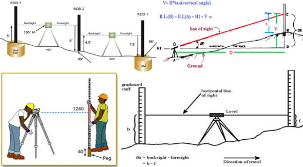
Details about leveling in surveying
Levelling is a branch of surveying, the object of which is to:
- Find the elevation of a given point with respect to the given or assumed datum.
- Establish a point at a given elevation with respect to the given or assumed datum.
Levelling is the parts and parcels of surveying and it is conducted on the following purposes :-
i) To find out the elevations of specified points on the basis of a prearranged or hypothetical datum.
ii) To set up points at a prearranged or hypothetical datum. The first point is essential to allow the works for being designed whereas the second point is essential in arranging all types of engineering works. Leveling takes care of measurements in a vertical plane.
Level surface: A surface parallel to the mean spheroid of the earth is called a level surface and the line drawn on the level surface is known as a level line. Hence all points lying on a level surface are equidistant from the centre of the earth. .A level surface means a curved surface that is perpendicular at each point to the direction of gravity at the point. The surface of a still water is a perfectly level surface. Any surface corresponding to the mean spheroidal surface of the earth is, therefore, called as level surface.
Level line: A level line stands for a line that rests in a level surface. So, it is normal to the plumb line at all points.
Horizontal plane: Horizontal plane through a point belongs to a plane that is tangential to the level surface at that point. So, It is perpendicular to the plumb line through the point.
Horizontal line: It belongs to a straight line tangential to the level line at a point. It is situated at a 90 degree angle to the plumb line.
Vertical line: It is a line normal to the level line at a point. It is generally treated as the line demarcated with a plumb line.
Datum: Datum belongs to any surface to which elevation are assigned. The mean sea level provides a smooth datum world over, and elevations are generally provided on over or underneath sea level. It is often more uncomplicated, however, to guess some other datum, specifically, if only the relevant elevation of points are necessary.
Elevation: The elevation of a point on or adjacent to the surface of the earth belongs to its vertical distance over or underneath a randomly accepted level surface or datum. The variation in elevation between two points belong to the vertical distance amid the two level surface in which the two points rest.
Vertical angle: Vertical angle refers to an angle among two bisecting lines in a vertical plane. Normally, one of these lines is horizontal.
Mean sea level: It belongs to the average height of the sea for all phases of the tides. At any specific place it is originated by averaging the hourly tide heights over a long period of 19 years.
Bench Mark: A benchmark is a relatively permanent reference point, the elevation of which is known (assumed or known w.r.t. MSL). It is used as a starting point for levelling or as a point upon which to close for a check. The following are the different types of benchmarks used in surveying:
(a) GTS benchmarks (b) Permanent benchmarks
(c) Arbitrary benchmarks and (d) Temporary benchmarks.
(a) GTS Benchmark: The long form of GTS benchmark is Great Trigonometrical Survey benchmark. These benchmarks are established by national agency. In India, the department of Survey of India is entrusted with such works. GTS benchmarks are established all over the country with highest precision survey, the datum being mean sea level. A bronze plate provided on the top of a concrete pedastal with elevation engraved on it serves as benchmark. It is well protected with masonry structure built around it so that its position is not disturbed by animals or by any unauthorised person. The position of GTS
benchmarks are shown in the topo sheets published.
(b) Permanent Benchmark: These are the benchmarks established by state government agencies like PWD. They are established with reference to GTS benchmarks. They are usually on the corner of plinth of public buildings.
(c) Arbitrary Benchmark: In many engineering projects the difference in elevations of neighbouring points is more important than their reduced level with respect to mean sea level. In such cases a relatively permanent point, like plinth of a building or corner of a culvert, are taken as benchmarks, their level assumed arbitrarily such as 100.0 m, 300.0 m, etc.
(d) Temporary Benchmark: This type of benchmark is established at the end of the day’s work, so that the next day work may be continued from that point. Such point should be on a permanent object so that next day it is easily identified.


